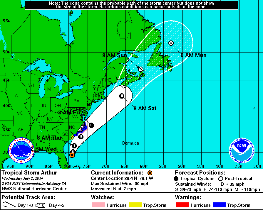
During the 3 p.m. conference call on Tropical Storm Arthur, National Weather Service warning coordinator meteorologist Steve Pfaff said there should be minimal effects to southeastern North Carolina from rain and wind as long as Arthur holds its current course.
With Arthur forecasted to pass 70 miles east of Cape Fear, the heaviest rain, wind and surf will remain on the east side of the storm and away from land.
However, Pfaff said it would be a significant event for maritime travel and for the many beachgoers flocking to area beaches for the Fourth of July holiday. Along its path Arthur is forecasted to produce 30-foot seas with large surf and strong rip currents along the shores of the Cape Fear area Thursday around midday to Friday.
The lower Cape Fear will begin to see winds and rainfall increase around noon Thursday, with the worst coming late afternoon into Thursday evening. Along the immediate coastline 40-55 mph winds are expected but only a total estimated rainfall of around 1-1.5 inches.
Pfaff said there would be a sharp drop off in rain accumulation further inland with possibly no rain falling on areas like Whiteville and points west.
A new update on Arthur’s track was that it has increased speed and will come closest to the Cape Fear around 8 p.m. Thursday evening.
Pfaff said Arthur is still forecasted to become a Category 1 hurricane once it reaches warmer water parallel to South Carolina and should continue on as a Category 1 as it passes by the northeastern United States this weekend.
Most of the modeling for Arthur’s path has been accurate but Pfaff warned that any shift to the west in its path could greatly increase the effects on southeastern North Carolina.
email [email protected]


