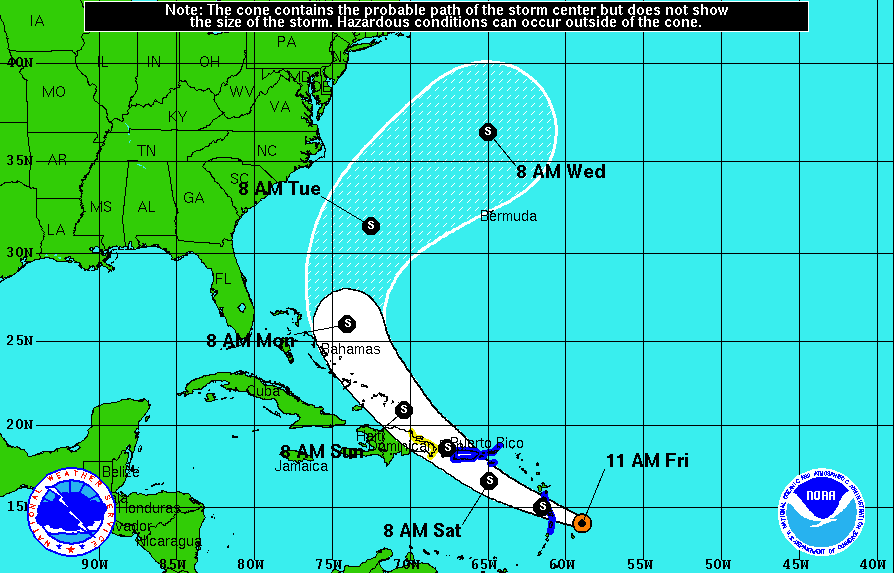
Tropical Storm Bertha, which formed late Thursday night in the Atlantic Ocean, continued on its projected path towards Barbados and the Lesser Antilles Friday.
As of the 5 p.m. Friday advisory issued by the National Hurricane Center, the storm was located at 14.9N 61.2W and moving west-northwest at 24 mph with maximum sustained winds of 50 mph.
The latest advisory showed the center of the storm located near the northern end of Martinique. A tropical storm watch has been issued for the southeastern Bahamas and the Turks and Caicos islands.
Bertha is expected to pass near Puerto Rico midday Saturday and continue to move northwest, tracking just north of the Dominican Republic by Sunday morning. Forecast models show minimal impact from rain and wind to the east coast of the United States, as the storm is not predicted to make landfall or strengthen to a hurricane.
Despite these predictions, meteorologist Steve Pfaff warned Wilmington residents to not get complacent.
“There is variability with the forecast track for every storm so we need to keep a cautious eye on it,” Pfaff said in a phone interview on Friday afternoon. “There’s a very low probability of a hurricane forming because of the interaction of dry air and wind shear aloft and it’s going to go over some islands…but I’m not saying it couldn’t happen.”
Pfaff said the biggest impact to the North Carolina coast will likely be rip currents and high surf. The tropical storm is forecast to be off the coast of North Carolina around 2 a.m. Tuesday, as it begins to make a northeasterly turn back out to sea.
Although Bertha is only the second named storm of the 2014 hurricane season, Pfaff stressed the importance of staying vigilant.
“We’re still in the early stages of hurricane season and the peak is September 10,” Pfaff said. “We have a history of having bad storms particularly as we head into August and September. We can’t let our guard down until we get to the end of October when the ocean cools down.”
Pfaff also pointed out that wind speed does not necessarily correlate with the amount of damage a storm causes. Hurricane Sandy, one of the deadliest hurricanes in history, was classified as post-tropical when it made landfall.
Hurricane Arthur, on the other hand, was a Category 1 as it passed just off the coast of southern North Carolina on July 3.
“One was a catastrophe, and one was basically a drill for us,” said Pfaff.
For the latest advisory information, visit http://www.nhc.noaa.gov
email [email protected]


