

When it comes to discussing the naval battles of World War II, attention often turns to the Pacific theater and battles for islands like Midway, but the Atlantic Ocean saw its fair share. Outside of WWII historians and the octogenarians who lived through the mandatory blackouts along the East Coast, few are aware of how close German U-Boats came to shore.
The wreckage of U-Boat 576 was discovered in August by a research team only 25 miles southeast of Ocracoke Island, along with the wreck of the Nicaraguan freighter Bluefields. The pair lie just 240 yards from each other.
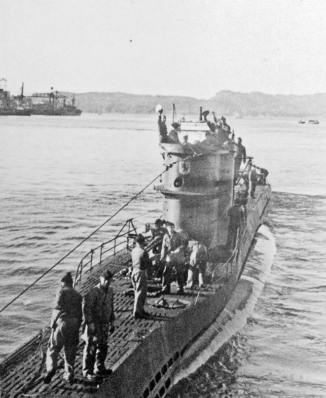
A group of 19 merchant ships escorted by the U.S. Navy and U.S. Coast Guard known as Convoy KS-520 was en route from Norfolk, Va., to Key West, Fla., delivering cargo in support of the war effort. On July 15, 1942, the convoy crossed the path of U-576 off Cape Hatteras. Rather than continue home for repairs to Germany, the Captain of the U-Boat attacked the convoy and surfaced in its midst, sinking the Bluefields and severely damaging two other ships.
The U.S. Navy Kingfisher aircraft providing the convoy’s air cover bombed U-576 as the merchant ship Unicoi attacked U-576 with its deck gun.
Badly damaged, both Bluefields and U-576 quickly sank to the bottom of the Atlantic where they remained for 70 years before being located.
One of the scientific investigators on the mission, John Bright, began studying the engagement as a graduate student enrolled in East Carolina University’s maritime studies program. Two of Bright’s professors, Drs. Tom Allen and Nathan Richards, began discussing the possibility of using Geographic Information Systems (GIS) to study naval battlefields.
“They started having conversations about applying it to archeological studies and came up with the idea of doing digital reconstructions of battlefields,” Bright said during a Nov. 11 phone interview from Colorado. “We can go to Gettysburg, we can stand on the battlefield … and observe it almost as it was at the time of the battle but the naval battlefields are more transient.”
While looking for a naval battle on which to test the method, Bright came across the wrecks of U-576 and Bluefields.
“We chose this particular engagement because it was an instance of a U-Boat attacking a convoy, but the convoy was defended by both surface ships and aircraft so we had multiple dimensions,” he said. “It was something complicated enough to put that technique to the test but not so complicated like the Battle of Midway where it would have taken us years to piece it together.”
In 2011, Bright and a team from ECU led one of the first search missions to begin to track down the wrecks. It was not until 2014 that the location of the vessels was confirmed using the GIS data and sonar after the National Oceanographic and Atmospheric Administration and Bureau of Ocean Energy Management became partners in the search.
Bright graduated from ECU in 2012 and was hired as an archeologist with the U.S. National Parks Service in Colorado but volunteered his time to assist with the 2014 mission.
“I had done all the research as a graduate student and had all the archival data and digital models we made of the battlefield; so as the NOAA team got involved I basically volunteered my time to update the work I had done to help them,” he said.
The expedition to locate the vessels took place in August after Hurricane Cristobal swept through the area. Bright said both side-scan sonar and multi-beam sonar were used to locate the wrecks.
“When we looked at it initially the default view of the sonar software program is to look straight at the object and it did not look like anything because the U-Boat was on its side,” Bright said. “Then we rotated the image and as soon as we did it was unmistakable.”
U-576 now lies on the seabed 690 feet deep, right where the continental shelf begins to fall away, and 240 yards further down the slope the Bluefields lies in 730 feet of water.
Although only U-576 contains human remains, both wrecks are considered war graves and Bright said they would never be disturbed or physically investigated. Just knowing his research helped spark the discovery of the two wrecks is enough for Bright.
“Most of your graduate school research ends up collecting dust after you print a copy off for you mom and dad,” Bright said. “Growing up in North Carolina public schools and reading David Stick’s ‘Graveyard of the Atlantic,’ it was one of those rare opportunities where I could make some type of contribution to history. It just started as a coffee table discussion at East Carolina University many years ago.”
email [email protected]


