

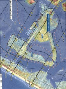
A coastal engineering firm has determined most of Wrightsville Beach’s Harbor Island is at lower risk for flooding during a hurricane than FEMA indicated in its preliminary flood zone maps.
Using different modeling techniques than FEMA, Applied Technology and Management (ATM) moved most of Harbor Island from a high-risk VE zone to a lower-risk AE zone in a report sent to town officials this week. Flood zones affect building requirements and flood insurance premiums.
The town hired ATM earlier this year to perform the study to determine whether the town had a case to appeal FEMA’s preliminary maps. ATM found FEMA used outdated and misrepresentative topographic data and misrepresentative modeling for wave regeneration.
ATM’s recommendation states “an appeal to the preliminary FEMA flood maps based on the current improved topographic data and modified [wave regeneration modeling] would very likely be successful in remapping a majority of the subject site into an AE flood zone.”
The decision whether to appeal will be on the Wrightsville Beach Board of Aldermen’s Sept. 10 meeting agenda.


