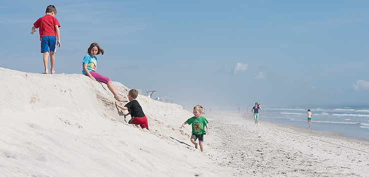
An escarpment, head-high in places, has greeted some beachgoers in Wrightsville Beach taking advantage of spring conditions early in March.
Erosion of this kind is expected after the storms and harsh conditions of the winter season, said town manager Tim Owens.
A wall of sand splitting the beach strand north of Johnnie Mercer’s Pier to the area of the Holiday Inn Resort indicates the coastal storm damage reduction project, which significantly widened the strand less than one year ago, is doing its job.
“That’s what it’s made to do. The beach is made to absorb those impacts, and that’s what you’re seeing. That’s the sacrificial part of the system,” Owens said. Although milder conditions should allow sand to naturally accrete back on the beach by summertime, approval recently secured from the N.C. Division of Coastal Management will allow the town to flatten the escarpment sooner with a front-end loader, he added.
Most beaches are subject to a natural cycle of erosion and accretion, agreed Spencer Rogers, N.C. Sea Grant construction and erosion specialist, but coastal management projects on Wrightsville Beach also impact the extent of erosion observed in places. Erosion north of Johnnie Mercer’s Pier looks more dramatic due to differences in the height of the beach strand immediately below the dunes, Rogers said, which is a consequence of Wrightsville’s coastal storm damage reduction project.
The dry, flat stretch of beach immediately below the dunes, known as the berm, is built up a few feet higher during each project. An unnourished beach quickly recovers from extensive seasonal erosion, Rogers said, but the stretch of berm built up during renourishment cannot naturally recover when erosion extends to the vegetation line, as it has this spring.
“When the erosion gets up into that higher berm, that adds three feet of elevation to the scarp. So it looks much more dramatic when the erosion gets that far back, and it doesn’t naturally recover on its own because the waves can’t reach that high under normal conditions,” Rogers said. The distinction is most noticeable around the northern boundary of the dune-building project, Rogers said, in front of The Islander condominium tower.
Another factor that contributes to more pronounced erosion in that area is closure of the old Moore’s Inlet bed, roughly located from Moore’s Inlet Drive north to Sand Dollar Lane, more than 50 years ago. The beachfront naturally curves from inlet to inlet, Rogers said, and the stretch of Wrightsville Beach around the old inlet bed is still recalibrating.
“Most North Carolina beaches are not straight. You think of them as being straight, but they’re actually curved. They curve from inlet to inlet, so when Moore’s Inlet existed, the older parts of Wrightsville Beach curved from Masonboro to Moore’s,” Rogers said. “After Moore’s Inlet closed, the curve wants to go from Masonboro Inlet to Masons Inlet, and that means it’s harder to keep sand on the northern end of the nourishment project.”
Some locally implemented solutions help curb erosion, like constructing sand fences along the dunes to trap sand caught in the wind, and planting vegetation to hold the dunes in place. The town fertilizes and plants along the dunes as needed, Owens said, and maintains sand fencing already in place.
“It’s a federal project, so there’s not much we can do,” Owens said. “We do try to keep folks out of the dunes, and we do some fertilization and keep whatever sand fence we have up, mended and fixed.”
email [email protected]


