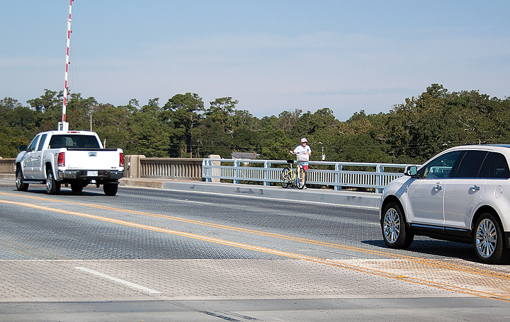
The Wrightsville Beach Board of Aldermen will address the issue of bike safety on the Heide Trask Drawbridge during its meeting Thursday, Oct. 9.
Although the item is on the consent agenda, it is an issue garnering attention because it affects cyclists, motorists and pedestrians. Wrightsville Beach regulations do not allow cyclists to ride on town sidewalks, but with no bike lane spanning the drawbridge, many cyclists feel unsafe navigating the metal grid while sharing the road with cars.
Wrightsville Beach resident Tim Taylor said he occasionally sees cyclists riding on sidewalks, weaving around kids and dogs, but he said many of them are simply not aware of the sidewalk regulations.
He acknowledged it was hard to ask bikers to stay off the sidewalks when the alternative, riding with traffic on the bridge, was so dangerous.
“Quite frankly, I do think it would be unsafe for them to ride in the road there unless they make more of a bike path,” Taylor said.
Cape Fear Cyclists president Richard Knight agreed, saying the key to motorists, cyclists and pedestrians sharing the roadways peacefully was having clear designated paths for each mode of transportation.
“I think it would help to have a definitive avenue [for cyclists],” Knight said during an Oct. 7 phone interview. “I don’t think it will be more than two or three feet wide, but then cars will understand that’s where the cyclists are supposed to be.”
Jim Iannucci also weighed in on the issue, speaking from the point of view of both a cyclist and a town engineer for New Hanover County. He suggested similar solutions, voicing concerns about the difficulty of riding across the metal rungs on the bridge, especially after a rainstorm.
“On the new grid, the metal stands up, they’re called nubs, and they’re a lot more pronounced,” Iannucci said during an Oct. 7 phone interview. “It’s more difficult to get a good line and ride across, so they might put a small mesh grid down … a flatter grid where bikes could go and signs that say ‘caution when wet.’”
A memo from the Cape Fear Cyclists and the Wilmington Urban Area Metropolitan Planning Organization asks the board to consider installing metal plates to create an even surface where cyclists can ride more comfortably and safely.
In addition to bike safety, the aldermen will also consider whether to challenge the new FEMA flood rate maps. Several residents have expressed concerns regarding the new flood designation for Harbor Island.
Harbor Island remains in the VE zone, while oceanfront and other east street properties, as well as the commercial businesses, including Kings Beachwear behind Johnnie Mercer’s Pier, were dropped from VE to the AE zone. Although Harbor Island’s low elevation could play a factor into its high-risk flood zone, residents and town officials question how Harbor Island could see higher wave action than oceanfront locations.
The board will hear a presentation on the maps by North Carolina Sea Grant’s Spencer Rogers, who has more than 30 years’ experience helping private property owners, builders, designers, and governmental agencies to develop hurricane-resistant techniques. Rogers will try to explain the maps and outline the appeals process.
email [email protected]


